Houston, we have a problem.
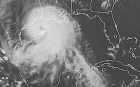
Here is the latest satellite image of Mr. Ike. A couple of observations. One, while he is not that high in the “category level,” (he will probably come ashore as a Cat 2 storm), he is a huge storm in terms of physical size. This does make a difference. This will mean higher waves and more flooding as the storm throws much more water to the northwest and north. Many parts of Louisiana have already experienced higher water levels and more flooding than from Hurricane Gustav.
Second, for those people who decided not to evacuate Galveston — I have one thing to say. I hope you wrote your social security number on your arm in indelible marker.
(Just one of the lessons learned from Hurricane Katrina.)
As for why Ike did not get as strong as many had predicted — my guess is water temperatures. When Katrina rolled across the Gulf of Mexico, temperatures in the Gulf were as high as the low 90s. Ike, on the other hand has had an average of only 82 degree temps to feast upon. Lower temperatures means less fuel for the machine.
But, like I say, while he may not be as intense as some storms, he makes up for it in sheer size.
Those of you in the Dallas Ft. Worth Metroplex may have a rough day tomorrow as well — depending upon how sharply Ike turns to the Northeast after hitting the coast. The good thing is that the Dallas area, for now, would be on the weaker side of the storm.
But — we’ll all know more tomorrow.
In the meantime — I’m back at the PlaneBusiness Worldwide Headquarters today, after a three-week stay in the Lone Star State. We’ve had intermittent heavy bands of rain and wind come rolling through all day as we continue to experience the “outer bands” of the storm on the Northeast side.
For all you folks who call the Houston area home, we’re thinking about you. May a pine tree not slice your house in two or crush your car, and may water not come within 6 inches of your back door. Much less inside the door.
jus sayin’.